
Thank you for supporting this site ❤️
Make a donation
Make a donation
Blair topographic map
Click on the map to display elevation.
Thank you for supporting this site ❤️
Make a donation
Make a donation
About this map
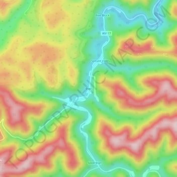
Name: Blair topographic map, elevation, terrain.
Location: Blair, Logan County, West Virginia, 25022, United States (37.85854 -81.84801 37.89854 -81.80801)
Average elevation: 426 m
Minimum elevation: 276 m
Maximum elevation: 583 m
Thank you for supporting this site ❤️
Make a donation
Make a donation
Other topographic maps
Click on a map to view its topography, its elevation and its terrain.
Greenville
United States > West Virginia > Logan County > Greenville > Hensley Heights
Average elevation: 371 m
Thank you for supporting this site ❤️
Make a donation
Make a donation