
Thank you for supporting this site ❤️
Make a donation
Make a donation
Góry Sowie topographic map
Click on the map to display elevation.
Thank you for supporting this site ❤️
Make a donation
Make a donation
Góry Sowie
Seen from the Silesian Lowlands in the northeast, the Owl Mountains form a comparatively steep edge of the Central Sudetes, though the range is very diversified in terms of height. The highest peaks are Wielka Sowa ("Great Owl", at 1,014 m (3,327 ft) in altitude) and Kalenica (964 m (3,163 ft)) with their observation towers. Other peaks reach heights from about 600 m (2,000 ft) to 980 m (3,220 ft) metres above sea level.
Thank you for supporting this site ❤️
Make a donation
Make a donation
About this map
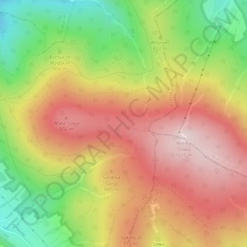
Name: Góry Sowie topographic map, elevation, terrain.
Average elevation: 831 m
Minimum elevation: 618 m
Maximum elevation: 1,011 m
Thank you for supporting this site ❤️
Make a donation
Make a donation