
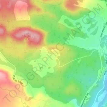
Craters of the Moon topographic map
Interactive map
Click on the map to display elevation.
About this map
Name: Craters of the Moon topographic map, elevation, terrain.
Average elevation: 441 m
Minimum elevation: 352 m
Maximum elevation: 543 m
Craters of the Moon is a steam field with a total of about 36 hectares (0.36 km2) of heated ground. It has an average altitude of 435 m. It has – of course – craters, but it also has fumaroles (“blowholes”) and a mudpool. Vegetation around the area of the Craters of the Moon is quite uncommon.
Other topographic maps
Click on a map to view its topography, its elevation and its terrain.
Tokaanu
New Zealand > Waikato > Taupo District
Tokaanu, Taupō District, Waikato, New Zealand
Average elevation: 409 m
Pokuru
New Zealand > Waikato > Taupo District
Pokuru, Taupo District, Waikato, New Zealand
Average elevation: 510 m
Wairakei Village
New Zealand > Waikato > Taupo District
Wairakei Village, Taupo District, Waikato, New Zealand
Average elevation: 407 m
Turangi
New Zealand > Waikato > Taupo District
Turangi, Taupo District, Waikato, 3334, New Zealand
Average elevation: 417 m