
Thank you for supporting this site ❤️
Make a donation
Make a donation
Corno Nero topographic map
Click on the map to display elevation.
Thank you for supporting this site ❤️
Make a donation
Make a donation
About this map
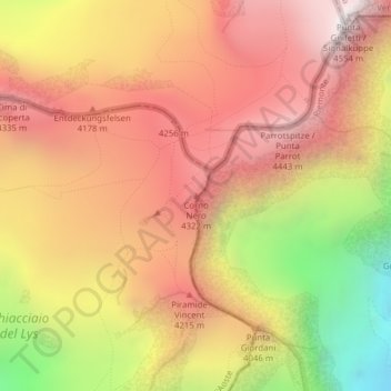
Name: Corno Nero topographic map, elevation, terrain.
Location: Corno Nero, Gressoney-La-Trinité, Valle d'Aosta, Italia (45.91492 7.86193 45.91502 7.86203)
Average elevation: 3,922 m
Minimum elevation: 2,974 m
Maximum elevation: 4,551 m
Thank you for supporting this site ❤️
Make a donation
Make a donation
Other topographic maps
Click on a map to view its topography, its elevation and its terrain.