
Champéry topographic map
Interactive map
Click on the map to display elevation.
About this map
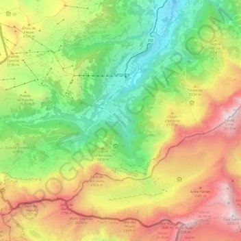
Name: Champéry topographic map, elevation, terrain.
Location: Champéry, Monthey, Valais/Wallis, 1874, Zwitserland (46.12927 6.79029 46.19007 6.91014)
Average elevation: 1,883 m
Minimum elevation: 820 m
Maximum elevation: 3,251 m
Other topographic maps
Click on a map to view its topography, its elevation and its terrain.
Les Crosets
Zwitserland > Valais/Wallis > Monthey > Val-d'Illiez
Les Crosets, Val-d'Illiez, Monthey, Valais/Wallis, 1873, Zwitserland
Average elevation: 1,773 m
Val-d'Illiez
Zwitserland > Valais/Wallis > Monthey > Val-d'Illiez > Val-d'Illiez
Val-d'Illiez, Monthey, Valais/Wallis, 1873, Zwitserland
Average elevation: 1,227 m
Val-d'Illiez
Zwitserland > Valais/Wallis > Monthey
Val-d'Illiez, Monthey, Valais/Wallis, 1873, Zwitserland
Average elevation: 1,672 m