
Thank you for supporting this site ❤️
Make a donation
Make a donation
Rudolph topographic map
Click on the map to display elevation.
Thank you for supporting this site ❤️
Make a donation
Make a donation
About this map
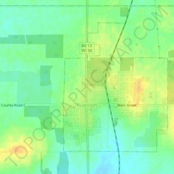
Name: Rudolph topographic map, elevation, terrain.
Location: Rudolph, Wood County, Wisconsin, United States (44.48880 -89.81277 44.50886 -89.79011)
Average elevation: 347 m
Minimum elevation: 334 m
Maximum elevation: 363 m
Thank you for supporting this site ❤️
Make a donation
Make a donation
Other topographic maps
Click on a map to view its topography, its elevation and its terrain.