
Thank you for supporting this site ❤️
Make a donation
Make a donation
Hales Creek topographic map
Click on the map to display elevation.
Thank you for supporting this site ❤️
Make a donation
Make a donation
About this map
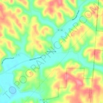
Name: Hales Creek topographic map, elevation, terrain.
Location: Hales Creek, Scioto County, Ohio, 45682, United States (38.79119 -82.69544 38.83119 -82.65544)
Average elevation: 229 m
Minimum elevation: 185 m
Maximum elevation: 282 m
Thank you for supporting this site ❤️
Make a donation
Make a donation
Other topographic maps
Click on a map to view its topography, its elevation and its terrain.