
Thank you for supporting this site ❤️
Make a donation
Make a donation
Mönsterås kommun topographic map
Click on the map to display elevation.
Thank you for supporting this site ❤️
Make a donation
Make a donation
About this map
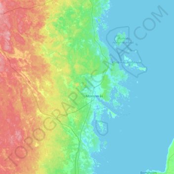
Name: Mönsterås kommun topographic map, elevation, terrain.
Location: Mönsterås kommun, Kalmar County, Sweden (56.87648 16.12045 57.24508 16.76405)
Average elevation: 26 m
Minimum elevation: -1 m
Maximum elevation: 109 m
Thank you for supporting this site ❤️
Make a donation
Make a donation
Other topographic maps
Click on a map to view its topography, its elevation and its terrain.