
Thank you for supporting this site ❤️
Make a donation
Make a donation
Dogwood Grove topographic map
Click on the map to display elevation.
Thank you for supporting this site ❤️
Make a donation
Make a donation
About this map
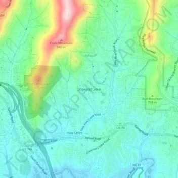
Name: Dogwood Grove topographic map, elevation, terrain.
Average elevation: 700 m
Minimum elevation: 612 m
Maximum elevation: 964 m
Thank you for supporting this site ❤️
Make a donation
Make a donation
Other topographic maps
Click on a map to view its topography, its elevation and its terrain.
Haw Creek Park
United States > North Carolina > Buncombe County > Asheville > Dogwood Grove
Average elevation: 666 m