
Thank you for supporting this site ❤️
Make a donation
Make a donation
Les Preuses topographic map
Click on the map to display elevation.
Thank you for supporting this site ❤️
Make a donation
Make a donation
About this map
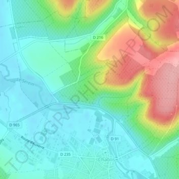
Name: Les Preuses topographic map, elevation, terrain.
Average elevation: 167 m
Minimum elevation: 126 m
Maximum elevation: 255 m
Thank you for supporting this site ❤️
Make a donation
Make a donation
Other topographic maps
Click on a map to view its topography, its elevation and its terrain.
Fyé
France > Bourgogne-Franche-Comté > Yonne > Chablis
Son altitude varie entre 126 et 311 mètres.
Average elevation: 215 m