
Thank you for supporting this site ❤️
Make a donation
Make a donation
Bridge of Dun topographic map
Click on the map to display elevation.
Thank you for supporting this site ❤️
Make a donation
Make a donation
About this map
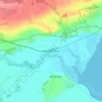
Name: Bridge of Dun topographic map, elevation, terrain.
Location: Bridge of Dun, Angus, Scotland, DD10 9LH, United Kingdom (56.69813 -2.57089 56.73813 -2.53089)
Average elevation: 22 m
Minimum elevation: -2 m
Maximum elevation: 80 m
Thank you for supporting this site ❤️
Make a donation
Make a donation
Other topographic maps
Click on a map to view its topography, its elevation and its terrain.
Thank you for supporting this site ❤️
Make a donation
Make a donation
Thank you for supporting this site ❤️
Make a donation
Make a donation
Thank you for supporting this site ❤️
Make a donation
Make a donation
Thank you for supporting this site ❤️
Make a donation
Make a donation