
Make a donation
Grüsch topographic map
Click on the map to display elevation.
Make a donation
About this map
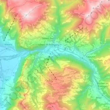
Name: Grüsch topographic map, elevation, terrain.
Location: Grüsch, Prättigau/Davos, Graubünden, Schweiz (46.91438 9.59366 47.02798 9.74330)
Average elevation: 1,210 m
Minimum elevation: 522 m
Maximum elevation: 2,349 m
Make a donation
Other topographic maps
Click on a map to view its topography, its elevation and its terrain.
Oberalp
Schweiz > Graubünden > Prättigau/Davos > Davos > Davos Monstein > Oberalp
Average elevation: 2,101 m
Make a donation
Sankt Antönien
Schweiz > Graubünden > Prättigau/Davos > Luzein
Den wichtigsten Wirtschaftszweig im Tal stellt die Landwirtschaft. Bedingt durch das alpine Klima, die Höhenlage und die Topographie ist kein wirtschaftlicher Ackerbau möglich, deshalb herrschen Fleisch- und Milchwirtschaft vor. Lange Tradition hat die Haltung von Kleinvieh, besonders Ziegen, was heute…
Average elevation: 1,721 m