
Thank you for supporting this site ❤️
Make a donation
Make a donation
Eski Emirler topographic map
Click on the map to display elevation.
Thank you for supporting this site ❤️
Make a donation
Make a donation
About this map
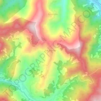
Name: Eski Emirler topographic map, elevation, terrain.
Location: Eski Emirler, Bartın, Black Sea Region, Turkey (41.34593 32.37248 41.38593 32.41248)
Average elevation: 549 m
Minimum elevation: 275 m
Maximum elevation: 805 m
Thank you for supporting this site ❤️
Make a donation
Make a donation