
Make a donation
Mansfield Woodhouse topographic map
Click on the map to display elevation.
Make a donation
About this map
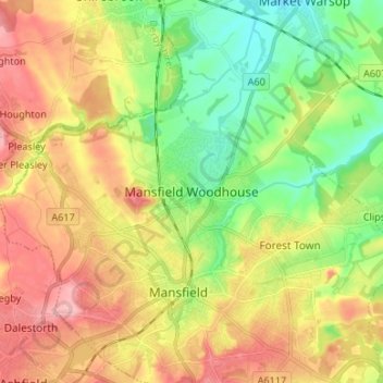
Name: Mansfield Woodhouse topographic map, elevation, terrain.
Average elevation: 114 m
Minimum elevation: 58 m
Maximum elevation: 177 m
Make a donation
Other topographic maps
Click on a map to view its topography, its elevation and its terrain.
Nottingham Canal
United Kingdom > England > Nottinghamshire > Nottingham > Beeston
Average elevation: 33 m
East Stoke CP
United Kingdom > England > Nottinghamshire > Newark and Sherwood
Average elevation: 24 m
Make a donation
Epperstone CP
United Kingdom > England > Nottinghamshire > Newark and Sherwood
The report notes Epperstone's "very distinctive character... a combination of topography, buildings, trees and walls.... The constantly changing views make it an attractive space to move through." It also notes, "The approach to the village from the west is along a tunnel formed by overhanging trees, including…
Average elevation: 69 m