
Thank you for supporting this site ❤️
Make a donation
Make a donation
Wemmel topographic map
Click on the map to display elevation.
Thank you for supporting this site ❤️
Make a donation
Make a donation
About this map
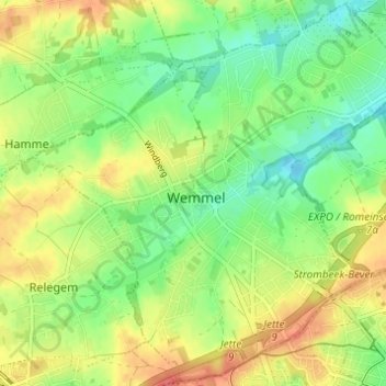
Name: Wemmel topographic map, elevation, terrain.
Location: Wemmel, Hal-Vilvorde, Brabant flamand, Flandre, Belgique (50.89039 4.27780 50.92560 4.33896)
Average elevation: 53 m
Minimum elevation: 27 m
Maximum elevation: 87 m
Thank you for supporting this site ❤️
Make a donation
Make a donation
Other topographic maps
Click on a map to view its topography, its elevation and its terrain.