
Hrishyamukh topographic map
Interactive map
Click on the map to display elevation.
About this map
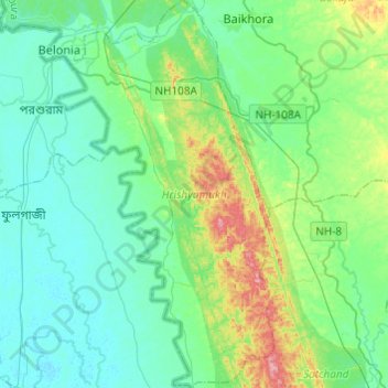
Name: Hrishyamukh topographic map, elevation, terrain.
Location: Hrishyamukh, South Tripura District, Tripura, 799156, Indien (23.05558 91.45278 23.27852 91.59156)
Average elevation: 33 m
Minimum elevation: 4 m
Maximum elevation: 134 m
Other topographic maps
Click on a map to view its topography, its elevation and its terrain.
Gandacherra
Indien > Tripura > Dumburnagar
Gandacherra, Dumburnagar, Dhalai District, Tripura, 799284, Indien
Average elevation: 114 m
Jampuii Hills
Jampuii Hills, North Tripura District, Tripura, 799269, Indien
Average elevation: 207 m