
Thank you for supporting this site ❤️
Make a donation
Make a donation
Ernsbach topographic map
Click on the map to display elevation.
Thank you for supporting this site ❤️
Make a donation
Make a donation
About this map
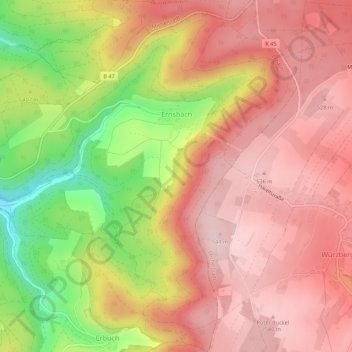
Name: Ernsbach topographic map, elevation, terrain.
Location: Ernsbach, Erbach, Odenwaldkreis, Hessen, 64711, Duitsland (49.63939 9.03786 49.67495 9.07457)
Average elevation: 447 m
Minimum elevation: 272 m
Maximum elevation: 548 m
Thank you for supporting this site ❤️
Make a donation
Make a donation