
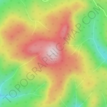
Mont de l'Ouest topographic map
Interactive map
Click on the map to display elevation.
About this map
Name: Mont de l'Ouest topographic map, elevation, terrain.
Average elevation: 714 m
Minimum elevation: 493 m
Maximum elevation: 921 m
Other topographic maps
Click on a map to view its topography, its elevation and its terrain.
Mont Pointu
Canada > Quebec > La Matanie > Rivière-Bonjour
Mont Pointu, Rivière-Bonjour, La Matanie, Bas-Saint-Laurent, Quebec, Canada
Average elevation: 649 m
Lac Beaulieu
Canada > Quebec > La Matanie > Rivière-Bonjour
Lac Beaulieu, Rivière-Bonjour, La Matanie, Bas-Saint-Laurent, Quebec, Canada
Average elevation: 721 m