
Thank you for supporting this site ❤️
Make a donation
Make a donation
Montalvo topographic map
Click on the map to display elevation.
Thank you for supporting this site ❤️
Make a donation
Make a donation
About this map
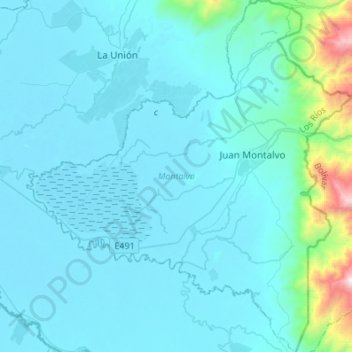
Name: Montalvo topographic map, elevation, terrain.
Location: Montalvo, Los Ríos, 120111, Ecuador (-1.93871 -79.46409 -1.66627 -79.21090)
Average elevation: 147 m
Minimum elevation: 2 m
Maximum elevation: 1,741 m
Thank you for supporting this site ❤️
Make a donation
Make a donation
Other topographic maps
Click on a map to view its topography, its elevation and its terrain.
San Jacinto de Buena Fe
Ecuador > Los Ríos > Buena Fe > San Jacinto de Buena Fe
Average elevation: 89 m
Thank you for supporting this site ❤️
Make a donation
Make a donation