
Thank you for supporting this site ❤️
Make a donation
Make a donation
Drom HaSharon Regional Council topographic map
Click on the map to display elevation.
Thank you for supporting this site ❤️
Make a donation
Make a donation
About this map
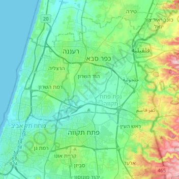
Name: Drom HaSharon Regional Council topographic map, elevation, terrain.
Average elevation: 58 m
Minimum elevation: -1 m
Maximum elevation: 284 m
Thank you for supporting this site ❤️
Make a donation
Make a donation
Other topographic maps
Click on a map to view its topography, its elevation and its terrain.
Thank you for supporting this site ❤️
Make a donation
Make a donation
Modiin-Maccabim-Reut
Israel > Center District > Ramla Subdistrict > Modiin-Maccabim-Reut
Average elevation: 240 m
Thank you for supporting this site ❤️
Make a donation
Make a donation