
Thank you for supporting this site ❤️
Make a donation
Make a donation
Perrysburg topographic map
Click on the map to display elevation.
Thank you for supporting this site ❤️
Make a donation
Make a donation
About this map
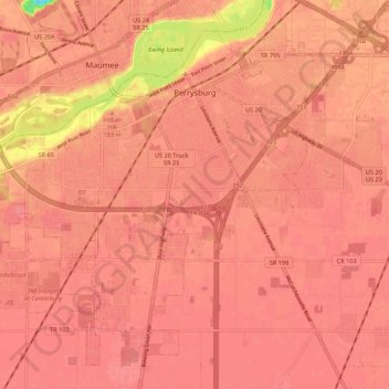
Name: Perrysburg topographic map, elevation, terrain.
Location: Perrysburg, Wood County, Ohio, 43551, United States (41.49994 -83.69994 41.57156 -83.59140)
Average elevation: 194 m
Minimum elevation: 139 m
Maximum elevation: 203 m
Thank you for supporting this site ❤️
Make a donation
Make a donation
Other topographic maps
Click on a map to view its topography, its elevation and its terrain.
Cedar Creek Woods
United States > Ohio > Wood County > Northwood > Cedar Creek Woods
Average elevation: 185 m