
Thank you for supporting this site ❤️
Make a donation
Make a donation
Bois du Breil topographic map
Click on the map to display elevation.
Thank you for supporting this site ❤️
Make a donation
Make a donation
About this map
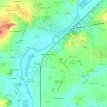
Name: Bois du Breil topographic map, elevation, terrain.
Average elevation: 20 m
Minimum elevation: 2 m
Maximum elevation: 62 m
Thank you for supporting this site ❤️
Make a donation
Make a donation
Other topographic maps
Click on a map to view its topography, its elevation and its terrain.
Étang de Chaumeray
France > Bretagne > Ille-et-Vilaine > Guipry-Messac > Chaumeray
Average elevation: 82 m