
Thank you for supporting this site ❤️
Make a donation
Make a donation
Padang Ratu topographic map
Click on the map to display elevation.
Thank you for supporting this site ❤️
Make a donation
Make a donation
About this map
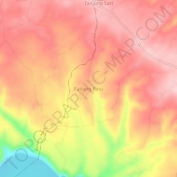
Name: Padang Ratu topographic map, elevation, terrain.
Average elevation: 664 m
Minimum elevation: 536 m
Maximum elevation: 721 m
Thank you for supporting this site ❤️
Make a donation
Make a donation
Other topographic maps
Click on a map to view its topography, its elevation and its terrain.
Thank you for supporting this site ❤️
Make a donation
Make a donation
Buay Pematang Ribu Ranau Tengah
Indonesia > South Sumatra > Ogan Komering Ulu Selatan
Average elevation: 670 m
Thank you for supporting this site ❤️
Make a donation
Make a donation
Thank you for supporting this site ❤️
Make a donation
Make a donation