
Thank you for supporting this site ❤️
Make a donation
Make a donation
Maria Enzersdorf topographic map
Click on the map to display elevation.
Thank you for supporting this site ❤️
Make a donation
Make a donation
About this map
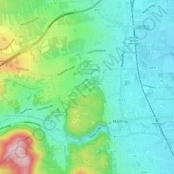
Name: Maria Enzersdorf topographic map, elevation, terrain.
Location: Maria Enzersdorf, Bezirk Mödling, Lower Austria, 2344, Austria (48.08199 16.25584 48.10468 16.31468)
Average elevation: 249 m
Minimum elevation: 194 m
Maximum elevation: 410 m
Thank you for supporting this site ❤️
Make a donation
Make a donation
Other topographic maps
Click on a map to view its topography, its elevation and its terrain.
Perchtoldsdorfer Heide
Austria > Lower Austria > Bezirk Mödling > Perchtoldsdorf
Average elevation: 312 m
Vorderer Kaufberg
Austria > Lower Austria > Bezirk Mödling > Gemeinde Breitenfurt bei Wien
Average elevation: 341 m
Sulz im Wienerwald
Austria > Lower Austria > Bezirk Mödling > Gemeinde Wienerwald
Average elevation: 459 m