
Thank you for supporting this site ❤️
Make a donation
Make a donation
Castel Boglione topographic map
Click on the map to display elevation.
Thank you for supporting this site ❤️
Make a donation
Make a donation
About this map
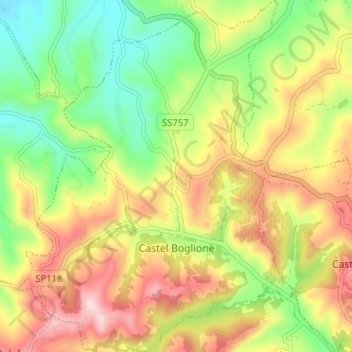
Name: Castel Boglione topographic map, elevation, terrain.
Location: Castel Boglione, Asti, Piedmont, Italy (44.70703 8.35050 44.75234 8.40101)
Average elevation: 285 m
Minimum elevation: 143 m
Maximum elevation: 452 m
Thank you for supporting this site ❤️
Make a donation
Make a donation
Other topographic maps
Click on a map to view its topography, its elevation and its terrain.