
Lake George topographic map
Interactive map
Click on the map to display elevation.
About this map
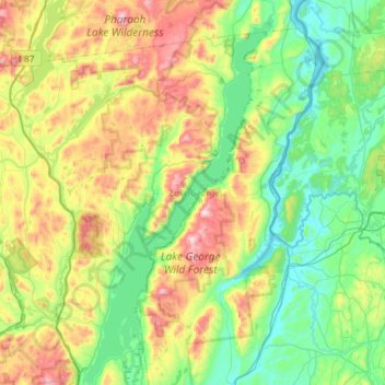
Name: Lake George topographic map, elevation, terrain.
Location: Lake George, New York, 12874, États-Unis (43.41740 -73.71259 43.83789 -73.42484)
Average elevation: 247 m
Minimum elevation: 24 m
Maximum elevation: 785 m
Other topographic maps
Click on a map to view its topography, its elevation and its terrain.
Adirondack
États-Unis > New York > Adirondack
Adirondack, Town of Horicon, Warren County, New York, 12808, États-Unis
Average elevation: 294 m
Malone
États-Unis > New York > Malone
Malone, Franklin County, New York, 12953, États-Unis
Average elevation: 231 m
Torrey
Torrey, Yates County, New York, 14441, États-Unis
Average elevation: 201 m
Washington County
Kingsbury, Washington County, New York, 12839, États-Unis
Average elevation: 77 m