
Thank you for supporting this site ❤️
Make a donation
Make a donation
Villavicencio topographic map
Click on the map to display elevation.
Thank you for supporting this site ❤️
Make a donation
Make a donation
About this map
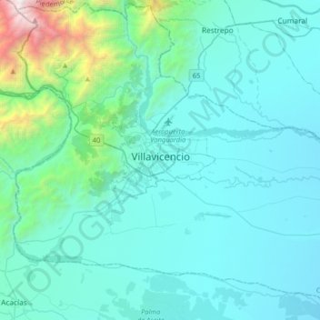
Name: Villavicencio topographic map, elevation, terrain.
Location: Villavicencio, Meta, 500005, Colombia (3.97151 -73.78067 4.29151 -73.46067)
Average elevation: 672 m
Minimum elevation: 299 m
Maximum elevation: 3,677 m
Thank you for supporting this site ❤️
Make a donation
Make a donation
Other topographic maps
Click on a map to view its topography, its elevation and its terrain.