
Thank you for supporting this site ❤️
Make a donation
Make a donation
Puspo topographic map
Click on the map to display elevation.
Thank you for supporting this site ❤️
Make a donation
Make a donation
About this map
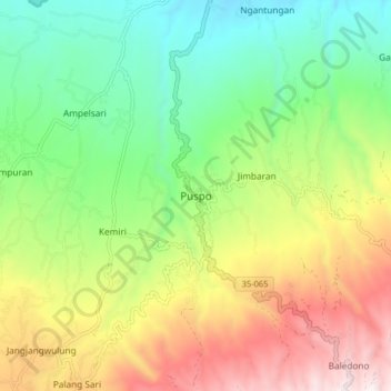
Name: Puspo topographic map, elevation, terrain.
Location: Puspo, Pasuruan, East Java, Java, Indonesia (-7.86898 112.82769 -7.78898 112.90769)
Average elevation: 694 m
Minimum elevation: 201 m
Maximum elevation: 1,451 m
Thank you for supporting this site ❤️
Make a donation
Make a donation
Other topographic maps
Click on a map to view its topography, its elevation and its terrain.