
Make a donation
Harrison topographic map
Click on the map to display elevation.
Make a donation
About this map
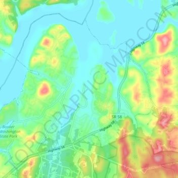
Name: Harrison topographic map, elevation, terrain.
Average elevation: 234 m
Minimum elevation: 200 m
Maximum elevation: 319 m
Make a donation
Other topographic maps
Click on a map to view its topography, its elevation and its terrain.
Glenwood
United States > Tennessee > Hamilton County > Chattanooga > Ridgeside
Average elevation: 229 m
Make a donation
Morrison Springs
United States > Tennessee > Hamilton County > Chattanooga > Red Bank
Average elevation: 327 m
Make a donation
Spring Valley
United States > Tennessee > Hamilton County > Chattanooga > Red Bank
Average elevation: 319 m
Eastdale
United States > Tennessee > Hamilton County > Chattanooga > Ridgeside
Average elevation: 237 m
Make a donation
Alpine Heights
United States > Tennessee > Hamilton County > Chattanooga > Red Bank
Average elevation: 249 m
Make a donation
Make a donation
Make a donation
Make a donation
Make a donation
Make a donation
Make a donation
Soddy-Daisy
United States > Tennessee > Hamilton County > Soddy-Daisy > Soddy-Daisy
Average elevation: 307 m
Forest Highlands
United States > Tennessee > Hamilton County > Chattanooga > Forest Highlands
Average elevation: 239 m
Make a donation
Knollwood
United States > Tennessee > Hamilton County > Chattanooga > Red Bank
Average elevation: 245 m
Pine Harbor Heights
United States > Tennessee > Hamilton County > Soddy-Daisy
Average elevation: 238 m
Make a donation