
Thank you for supporting this site ❤️
Make a donation
Make a donation
Ynysybwl topographic map
Click on the map to display elevation.
Thank you for supporting this site ❤️
Make a donation
Make a donation
About this map
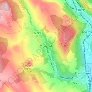
Name: Ynysybwl topographic map, elevation, terrain.
Location: Ynysybwl, Rhondda Cynon Taf, Wales, CF37 3HR, United Kingdom (51.61877 -3.37902 51.65877 -3.33902)
Average elevation: 209 m
Minimum elevation: 61 m
Maximum elevation: 361 m
Thank you for supporting this site ❤️
Make a donation
Make a donation
Other topographic maps
Click on a map to view its topography, its elevation and its terrain.
Thank you for supporting this site ❤️
Make a donation
Make a donation
Thank you for supporting this site ❤️
Make a donation
Make a donation