
Thank you for supporting this site ❤️
Make a donation
Make a donation
Vöhrenbach topographic map
Click on the map to display elevation.
Thank you for supporting this site ❤️
Make a donation
Make a donation
About this map
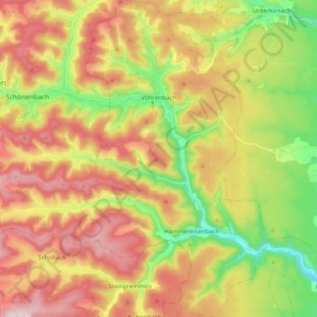
Name: Vöhrenbach topographic map, elevation, terrain.
Average elevation: 929 m
Minimum elevation: 723 m
Maximum elevation: 1,141 m
Thank you for supporting this site ❤️
Make a donation
Make a donation
Other topographic maps
Click on a map to view its topography, its elevation and its terrain.
Escheck
Germany > Baden-Württemberg > Schwarzwald-Baar-Kreis > Furtwangen im Schwarzwald
Average elevation: 1,011 m
Gremmelsbach
Germany > Baden-Württemberg > Schwarzwald-Baar-Kreis > Triberg im Schwarzwald > Gremmelsbach
Average elevation: 776 m