
Make a donation
Lopez Lake topographic map
Click on the map to display elevation.
Make a donation
About this map
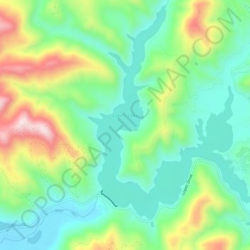
Name: Lopez Lake topographic map, elevation, terrain.
Average elevation: 249 m
Minimum elevation: 105 m
Maximum elevation: 539 m
Make a donation
Other topographic maps
Click on a map to view its topography, its elevation and its terrain.
Riverside
United States of America > California > Riverside
Riverside is the 59th largest city in the United States, the 12th largest city in California, and the largest city in California's Inland Empire metro area. According to the United States Census Bureau, the city has a total area of 81.4 square miles (210.8 km2), of which 81.1 square miles (210 km2) is land and…
Average elevation: 351 m
Lake Elsinore
United States of America > California > Lake Elsinore
The rainfall until 1893 was greater than normal, and the lake remained high and overflowed naturally on three or four occasions during that time. The lake water was purchased by the Temescal Water Company for the irrigation of land in Corona. Its outlet channel was deepened, permitting gravity flow down the…
Average elevation: 531 m
Beaumont
United States of America > California > Beaumont
Beaumont is a city in Riverside County, California, United States, located at a half-mile elevation in the pass area south of Southern California's highest peak, San Gorgonio Mountain, and north of San Jacinto Peak.
Average elevation: 725 m
Make a donation
Make a donation
Palmdale
United States of America > California > Palmdale
Downtown Palmdale is located at 34°34′46″N 118°07′00″W / 34.57944°N 118.11667°W / 34.57944; -118.11667, at an elevation of 2,655 feet (809 m) above sea level.
Average elevation: 898 m