
Thank you for supporting this site ❤️
Make a donation
Make a donation
Malakasa topographic map
Click on the map to display elevation.
Thank you for supporting this site ❤️
Make a donation
Make a donation
About this map
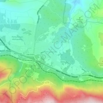
Name: Malakasa topographic map, elevation, terrain.
Average elevation: 316 m
Minimum elevation: 146 m
Maximum elevation: 691 m
Thank you for supporting this site ❤️
Make a donation
Make a donation
Other topographic maps
Click on a map to view its topography, its elevation and its terrain.
Kalyvia Thorikou Municipal Unit
Greece > Attica > Regional Unit of East Attica
Average elevation: 132 m
Thank you for supporting this site ❤️
Make a donation
Make a donation
Municipality of Vari - Voula - Vouliagmeni
Greece > Attica > Regional Unit of East Attica
Average elevation: 49 m
Dioni
Greece > Attica > Regional Unit of East Attica > Pikermi Municipal Unit
Average elevation: 241 m
Thank you for supporting this site ❤️
Make a donation
Make a donation
Municipality of Vari - Voula - Vouliagmeni
Greece > Attica > Regional Unit of East Attica
Average elevation: 49 m
Thank you for supporting this site ❤️
Make a donation
Make a donation
Gerakas Municipal Unit
Greece > Attica > Regional Unit of East Attica > Gerakas Municipal Unit
Average elevation: 259 m
Thank you for supporting this site ❤️
Make a donation
Make a donation