
Thank you for supporting this site ❤️
Make a donation
Make a donation
Roxas topographic map
Click on the map to display elevation.
Thank you for supporting this site ❤️
Make a donation
Make a donation
About this map
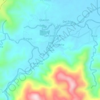
Name: Roxas topographic map, elevation, terrain.
Location: Roxas, Viga, Catanduanes, Bicol Region, 4805, Philippines (13.82847 124.26481 13.86847 124.30481)
Average elevation: 99 m
Minimum elevation: 2 m
Maximum elevation: 442 m
Thank you for supporting this site ❤️
Make a donation
Make a donation