
Saint-Joseph topographic map
Interactive map
Click on the map to display elevation.
About this map
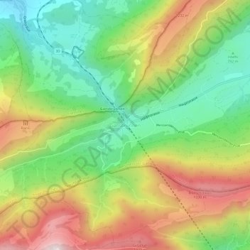
Name: Saint-Joseph topographic map, elevation, terrain.
Average elevation: 961 m
Minimum elevation: 619 m
Maximum elevation: 1,421 m
Other topographic maps
Click on a map to view its topography, its elevation and its terrain.
Parc naturel Thal
Suisse > Soleure > Amtei Thal-Gäu > Aedermannsdorf
Parc naturel Thal, Aedermannsdorf, Bezirk Thal, Amtei Thal-Gäu, Soleure, 4714, Suisse
Average elevation: 642 m