
Make a donation
Chelan County topographic map
Click on the map to display elevation.
Make a donation
About this map
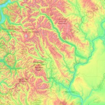
Name: Chelan County topographic map, elevation, terrain.
Location: Chelan County, Washington, United States (47.26094 -121.18091 48.55095 -119.85971)
Average elevation: 1,094 m
Minimum elevation: 70 m
Maximum elevation: 3,185 m
Make a donation
Other topographic maps
Click on a map to view its topography, its elevation and its terrain.
Mount Saint Helens
United States > Washington > Skamania County
The Mount St. Helens major eruption of May 18, 1980 remains the deadliest and most economically destructive volcanic event in U.S. history. Fifty-seven people were killed; 200 homes, 47 bridges, 15 miles (24 km) of railways, and 185 miles (298 km) of highway were destroyed. A massive debris avalanche,…
Average elevation: 2,096 m
Mount Olympus
United States > Washington > Jefferson County
With notable local relief, Mount Olympus ascends over 2,100 m (6,900 ft) from the 293 m (961 ft) elevation confluence of the Hoh River with Glacier Creek in only 8.8 km (5.5 mi). Mount Olympus has 2,386 m (7,828 ft) of prominence, ranking 5th in the state of Washington.
Average elevation: 1,934 m
Make a donation
Lake River
United States > Washington > Clark County > Ridgefield
Lake River, a "slow, flat slough of the Columbia River", loses only 1 foot (30 cm) in elevation over its entire 11-mile (18 km) course. It flows north, roughly parallel to the Columbia until curving slightly northwest to join it. At times, tidal fluctuations and high flows along the Columbia cause Lake River…
Average elevation: 35 m
Make a donation
Make a donation
Cathedral Rock
United States > Washington > Kittitas County
Cathedral Rock is an intrusive andesite volcanic complex. The Alpine Lakes Wilderness features some of the most rugged topography in the Cascade Range with craggy peaks and ridges, deep glacial valleys, and granite walls spotted with over 700 mountain lakes. Geological events occurring many years ago created…
Average elevation: 1,547 m
Make a donation
Glacier Peak
United States > Washington > Snohomish County
Despite its elevation of 10,541 feet (3,213 m), Glacier Peak is a small stratovolcano. Its relatively high summit is a consequence of its location atop a high ridge, but its volcanic portion extends only 1,600–3,200 feet (500–1,000 m) above the underlying ridge. Another Cascade Arc volcano with similar…
Average elevation: 2,656 m
Make a donation
Hot Springs
United States > Washington > King County
Hot Springs is located east of Enumclaw and just west of Lester, along the Green River and BNSF Railway line. Its elevation is 1512 feet (460m) above sea level.
Average elevation: 588 m
Make a donation
Make a donation
Roosevelt Beach Conservation Area
United States > Washington > Grays Harbor County > Ocean Grove
Average elevation: 18 m
Stampede Pass
United States > Washington > King County
Stampede Pass (elevation 3,672 feet (1,119 m)) is a mountain pass in the northwest United States, through the Cascade Range in Washington. Southeast of Seattle and east of Tacoma, its importance to transportation lies almost entirely with railroading, as no paved roads cross it. It is approximately twelve…
Average elevation: 1,135 m
Make a donation
Mica Peak
United States > Washington > Spokane County
Mica Peak is the name of two separate mountain summits in the United States located approximately 5.49 miles (9 km) apart; one in Spokane County, Washington and the other in Kootenai County, Idaho. The two peaks are located along the same ridge, which separates the Spokane Valley and Rathdrum Prairie from the…
Average elevation: 1,311 m
Mount Adams
United States > Washington > Yakima County
Adams is one of the long-lived volcanoes in the Cascade Range, with minor activity beginning 900,000 years ago and major cone building activity beginning 520,000 years ago. The whole mountain has been completely eroded by glaciers to an elevation of 8,200 feet (2,500 m) twice during its lifetime. The current…
Average elevation: 3,235 m
Make a donation
Salmon Creek Regional Park
United States > Washington > Clark County > Vancouver
Average elevation: 48 m
Make a donation
Make a donation
Make a donation
West Hylebos Wetlands Park
United States > Washington > King County > Federal Way
Average elevation: 84 m
Make a donation
Mount Saint Helens
United States > Washington > Skamania County
The Mount St. Helens major eruption of May 18, 1980 is currently the most economically destructive volcanic event in U.S. history. Fifty-seven people were killed; 200 homes, 47 bridges, 15 miles (24 km) of railways, and 185 miles (298 km) of highway were destroyed. A massive debris avalanche, triggered by a…
Average elevation: 2,096 m
Centralia Coal Mine Dam No 32B
United States > Washington > Thurston County > Tono
Average elevation: 104 m
Make a donation
Seattle viewpoint
United States > Washington > Kitsap County > Bainbridge Island
Average elevation: 20 m
Make a donation
Make a donation
Make a donation
Make a donation
Make a donation
Make a donation
Make a donation
Mount Ellinor
United States > Washington > Mason County
Mount Ellinor is a peak in the Olympic Mountains of Washington, United States. It is located in an area designated as the Mount Skokomish Wilderness. The mountain is a popular day hike in the summer months; the summit is reachable via a steep-but-brief 3.3-mile (5.3 km) trail which gains about 3,200 feet (980…
Average elevation: 1,334 m
Observatory Hill State Park
United States > Washington > Klickitat County > Goldendale
Average elevation: 540 m
Make a donation
Make a donation
Skyline Home Owners Association
United States > Washington > Skagit County > Anacortes
Average elevation: 14 m
Make a donation
Make a donation