
Make a donation
Deka Lake topographic map
Click on the map to display elevation.
Make a donation
About this map
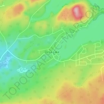
Name: Deka Lake topographic map, elevation, terrain.
Average elevation: 1,141 m
Minimum elevation: 1,071 m
Maximum elevation: 1,260 m
Make a donation
Other topographic maps
Click on a map to view its topography, its elevation and its terrain.
Horse Lake
Canada > British Columbia > Cariboo Regional District > Area L (Lone Butte/Interlakes)
Average elevation: 1,097 m
Needa Lake
Canada > British Columbia > Cariboo Regional District > Area L (Lone Butte/Interlakes)
Average elevation: 1,192 m
Sheridan Lake
Canada > British Columbia > Cariboo Regional District > Area L (Lone Butte/Interlakes)
Average elevation: 1,127 m
Interlakes
Canada > British Columbia > Cariboo Regional District > Area L (Lone Butte/Interlakes)
Average elevation: 1,126 m
Make a donation
Bridge Lake
Canada > British Columbia > Cariboo Regional District > Area L (Lone Butte/Interlakes)
Average elevation: 1,158 m