
Thank you for supporting this site ❤️
Make a donation
Make a donation
Sonoma Valley topographic map
Click on the map to display elevation.
Thank you for supporting this site ❤️
Make a donation
Make a donation
About this map
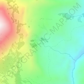
Name: Sonoma Valley topographic map, elevation, terrain.
Location: Sonoma Valley, Humboldt County, Nevada, United States (40.83986 -117.57737 40.85226 -117.56656)
Average elevation: 2,052 m
Minimum elevation: 1,756 m
Maximum elevation: 2,587 m
Thank you for supporting this site ❤️
Make a donation
Make a donation
Other topographic maps
Click on a map to view its topography, its elevation and its terrain.
Thank you for supporting this site ❤️
Make a donation
Make a donation
McDermitt
United States > Nevada > Humboldt County
The community is on U.S. Highway 95, 73 miles (117 km) north of Winnemucca. The elevation of McDermitt is 4,432 feet (1,351 m) above sea level.
Average elevation: 1,359 m
Thank you for supporting this site ❤️
Make a donation
Make a donation
Winnemucca
United States > Nevada > Humboldt County > Winnemucca > Winnemucca
Average elevation: 1,403 m