
Laki Beach topographic map
Click on the map to display elevation.
About this map
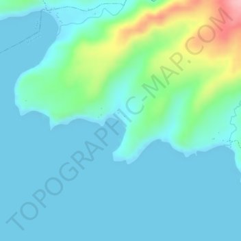
Name: Laki Beach topographic map, elevation, terrain.
Location: Laki Beach, Mariveles, Bataan, Central Luzon, Philippines (14.45750 120.39969 14.45956 120.40177)
Average elevation: 30 m
Minimum elevation: 0 m
Maximum elevation: 157 m
Other topographic maps
Click on a map to view its topography, its elevation and its terrain.
Mount Mariveles
Philippines > Bataan > Mariveles
Mount Mariveles is a massive stratovolcano topped with a 4-kilometre (2.5 mi) summit caldera which drains to the north. The highest peak, called Mariveles, has an elevation of 1,388 metres (4,554 ft) asl. Mounts Pantingan, Bataan, Tarak, and Vintana are the other peaks of the volcano-caldera complex, which has…
Average elevation: 879 m