
Thank you for supporting this site ❤️
Make a donation
Make a donation
El Tunal topographic map
Click on the map to display elevation.
Thank you for supporting this site ❤️
Make a donation
Make a donation
About this map
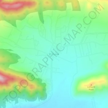
Name: El Tunal topographic map, elevation, terrain.
Location: El Tunal, Arteaga, Coahuila, México (25.40019 -100.65489 25.44019 -100.61489)
Average elevation: 2,330 m
Minimum elevation: 2,212 m
Maximum elevation: 2,630 m
Thank you for supporting this site ❤️
Make a donation
Make a donation
Other topographic maps
Click on a map to view its topography, its elevation and its terrain.
plaza de San Antonio de las Alazanas
México > Coahuila > Arteaga > San Antonio de Las Alazanas
Average elevation: 2,195 m