
Little Zab River topographic map
Interactive map
Click on the map to display elevation.
About this map
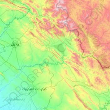
Name: Little Zab River topographic map, elevation, terrain.
Location: Little Zab River, Iraqi Kurdistan Region, Iraq (35.23639 43.42735 36.78356 45.61858)
Average elevation: 943 m
Minimum elevation: 172 m
Maximum elevation: 3,566 m
The Little Zab rises in the Zagros Mountains in Iran at an elevation of circa 3,000 metres (9,800 ft) amsl. In its upper reaches, the course of the Little Zab is determined by the alignment of the major mountain chains that make up the Zagros. Thus, the river flows through valleys that are predominantly aligned along a northwest–southeast axis, parallel to the major mountain chains of the Zagros, only to change its direction abruptly where it cuts through these chains in narrow gorges. Along the way, it collects the waters coming down from the eastern face of the Qandil Mountains, which now form the border between Iran and Iraq. The Little Zab enters the Mesopotamian plain south of Dukan, where it first assumes a roughly westward course before turning to the southwest upstream from the town of Altun Kopru and uniting with the Tigris near the town of Al Zab. Most tributaries join the Little Zab upstream from Dukan, with the largest being the Baneh River and the Qala Chulan. A number of smaller streams joined the Little Zab in the Ranya Plain, which is now partly inundated by Lake Dukan.
Other topographic maps
Click on a map to view its topography, its elevation and its terrain.
Great Mir Asfahan
Great Mir Asfahan, Altun Kupri Subdistrict, Dibis District, Kirkuk Governorate, Iraq
Average elevation: 339 m
Qadir Karam Subdistrict
Iraq > Sulaymaniyah Governorate
Qadir Karam Subdistrict, Chamchamal District, Sulaymaniyah Governorate, Iraqi Kurdistan Region, Iraq
Average elevation: 501 m
Bashiqa
Bashiqa, Bashiqa Subdistrict, Mosul District, Nineveh Governorate, Iraq
Average elevation: 400 m
Malihah
Malihah, Al-Rawah Central Subdistrict, Al-Rawah District, Al-Anbar Governorate, Iraq
Average elevation: 297 m
Qaryat Annan
Qaryat Annan, Al-Hillah Central Subdistrict, Al-Hillah District, Babil Governorate, 51001, Iraq
Average elevation: 33 m
Lake Tharthar
Lake Tharthar, Saladin Governorate, Iraq
Average elevation: 85 m
Nimrud
Iraq > Nineveh Governorate > Qaryat an Namaniyah
Nimrud, Qaryat an Namaniyah, Nimrud Subdistrict, Al-Hamdaniya District, Nineveh Governorate, Iraq
Average elevation: 203 m
Mergasur District
Mergasur District, Erbil Governorate, Iraqi Kurdistan Region, Iraq
Average elevation: 1,349 m
Nile
Iraq > Baghdad Governorate > Baghdad
Nile, Palestine Subdistrict, Al-Rusafa District, Baghdad, Al-Rusafa Municipality, Baghdad Governorate, 10045, Iraq
Average elevation: 37 m
Citadel of Erbil
Iraq > Erbil Governorate > Erbil
Citadel of Erbil, Citadel Street, Arab Quarter (105), Erbil, Erbil Central Subdistrict, Erbil District, Erbil Governorate, Iraqi Kurdistan Region, 44001, Iraq
Average elevation: 410 m
Bakrajo
Iraq > Sulaymaniyah Governorate
Bakrajo, Bakrajo subdistrict, Sulaymaniyah District, Sulaymaniyah Governorate, Iraqi Kurdistan Region, 46011, Iraq
Average elevation: 750 m
Al-Rumaithah District
Iraq > Al-Muthanna Governorate
Al-Rumaithah District, Al-Muthanna Governorate, Iraq
Average elevation: 16 m
Topzawa
Iraq > Sulaymaniyah Governorate
Topzawa, Dokan Central Subdistrict, Dokan District, Sulaymaniyah Governorate, Iraqi Kurdistan Region, Iraq
Average elevation: 632 m
Dashti
Iraq > Sulaymaniyah Governorate
Dashti, Mawat Central Subdistrict, Mawat District, Sulaymaniyah Governorate, Iraqi Kurdistan Region, Iraq
Average elevation: 1,009 m
Ghulami Lower Old
Iraq > Halabja Governorate > Halabja District
Ghulami Lower Old, Sirwan Sub-District, Halabja District, Halabja Governorate, Iraqi Kurdistan Region, 46018, Iraq
Average elevation: 531 m
Darbandikhan
Iraq > Sulaymaniyah Governorate
Darbandikhan, Darbandikhan Central Subdistrict, Darbandikhan District, Sulaymaniyah Governorate, Iraqi Kurdistan Region, 46020, Iraq
Average elevation: 584 m
Baqubah
Baqubah, Ba'quba Central Subdistrict, Ba'quba District, Diyala Governorate, 32010, Iraq
Average elevation: 45 m
Al-Adhamiyah District
Iraq > Baghdad Governorate > Baghdad
Al-Adhamiyah District, Baghdad, Al-Sha'ab Municipality, Baghdad Governorate, Iraq
Average elevation: 38 m
Qada Raniyah
Iraq > Sulaymaniyah Governorate
Qada Raniyah, Chwar Qurna Subdistrict, Ranya District, Sulaymaniyah Governorate, Iraqi Kurdistan Region, Iraq
Average elevation: 1,075 m
Erbil
Erbil, Erbil Central Subdistrict, Erbil District, Erbil Governorate, Iraqi Kurdistan Region, 44001, Iraq
Average elevation: 462 m
Al Rasheed Camp
Iraq > Baghdad Governorate > Baghdad
Al Rasheed Camp, Zaefarania Subdistrict, Al-Rusafa District, Baghdad, Baghdad Governorate, Iraq
Average elevation: 36 m
حي الشرطة
حي الشرطة, Al-Najaf Central Subdistrict, Al-Najaf District, Al-Najaf Governorate, Iraq
Average elevation: 46 m
Sarnawan
Iraq > Sulaymaniyah Governorate
Sarnawan, Penjwen Central Subdistrict, Penjwen District, Sulaymaniyah Governorate, Iraqi Kurdistan Region, Iraq
Average elevation: 1,393 m
Minaret Park
Minaret Park, Erbil, Erbil Central Subdistrict, Erbil District, Iraqi Kurdistan Region, 44001, Iraq
Average elevation: 404 m
Banaman
Banaman, Pirmam Subdistrict, Shaqlawa District, Erbil Governorate, Iraqi Kurdistan Region, 11000, Iraq
Average elevation: 770 m
ئالمەوانی بچووم
ئالمەوانی بچووم, Pirmam Subdistrict, Shaqlawa District, Erbil Governorate, Iraqi Kurdistan Region, 11000, Iraq
Average elevation: 859 m
Faisal Iyaman
Faisal Iyaman, Khanaqin Central Subdistrict, Khanaqin District, Diyala Governorate, Iraq
Average elevation: 230 m
Sahl Hawran
Iraq > Al-Anbar Governorate > Ayn Zagtah
Sahl Hawran, Ayn Zagtah, Al-Baghdadi Subdistrict, Hit District, Al-Anbar Governorate, Iraq
Average elevation: 164 m
Al-Diwaniyah District
Iraq > Al-Qadisiyah Governorate
Al-Diwaniyah District, Al-Qadisiyah Governorate, Iraq
Average elevation: 22 m
Nasiriyah
Nasiriyah, Al-Nasiriyah Central Subdistrict, Al-Nasiriyah District, Dhi Qar Governorate, 64002, Iraq
Average elevation: 5 m
Baste
Iraq > Sulaymaniyah Governorate
Baste, Zharawa Subdistrict, Pshdar District, Sulaymaniyah Governorate, Iraqi Kurdistan Region, Iraq
Average elevation: 1,016 m
Al-Karkh District
Iraq > Baghdad Governorate > Baghdad
Al-Karkh District, Baghdad, Al-Rashid Municipality, Baghdad Governorate, Iraq
Average elevation: 36 m
Weze
Weze, Choman Central Subdistrict, Choman District, Erbil Governorate, Iraqi Kurdistan Region, Iraq
Average elevation: 2,097 m
Tall Zuaitit
Tall Zuaitit, Bani Saad Subdistrict, Ba'quba District, Diyala Governorate, Iraq
Average elevation: 39 m