
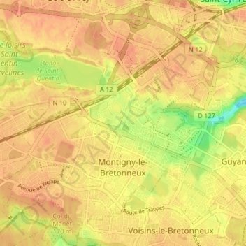
Montigny-le-Bretonneux topographic map
Interactive map
Click on the map to display elevation.
About this map
Name: Montigny-le-Bretonneux topographic map, elevation, terrain.
Average elevation: 164 m
Minimum elevation: 134 m
Maximum elevation: 176 m
La superficie de la commune est de 1 165 hectares ; son altitude varie de 150 à 171 mètres.
Other topographic maps
Click on a map to view its topography, its elevation and its terrain.
Notre-Dame-de-la-Mer
France > Île-de-France > Yvelines
Notre-Dame-de-la-Mer, Mantes-la-Jolie, Yvelines, Île-de-France, France métropolitaine, 78270, France
Average elevation: 81 m
Le Bois des Roches
France > Île-de-France > Yvelines > Magny-les-Hameaux
Le Bois des Roches, Magny-les-Hameaux, Rambouillet, Yvelines, Île-de-France, France métropolitaine, 78114, France
Average elevation: 152 m
La Celle-Saint-Cloud
France > Île-de-France > Yvelines
La Celle-Saint-Cloud, Versailles, Yvelines, Île-de-France, France métropolitaine, 78170, France
Average elevation: 141 m
Vernouillet
France > Île-de-France > Yvelines
Vernouillet, Saint-Germain-en-Laye, Yvelines, Île-de-France, France métropolitaine, 78540, France
Average elevation: 57 m
Les Alluets-le-Roi
France > Île-de-France > Yvelines > Les Alluets-le-Roi
Les Alluets-le-Roi, Saint-Germain-en-Laye, Yvelines, Île-de-France, France métropolitaine, 78580, France
Average elevation: 163 m
Osmoy
France > Île-de-France > Yvelines > Osmoy
Osmoy, Mantes-la-Jolie, Yvelines, Île-de-France, France métropolitaine, 78910, France
Average elevation: 116 m
Grosrouvre
France > Île-de-France > Yvelines > Grosrouvre
Grosrouvre, Rambouillet, Yvelines, Île-de-France, France métropolitaine, 78490, France
Average elevation: 165 m
Villennes-sur-Seine
France > Île-de-France > Yvelines > Villennes-sur-Seine
Villennes-sur-Seine, Saint-Germain-en-Laye, Yvelines, Île-de-France, France métropolitaine, 78670, France
Average elevation: 64 m
Louveciennes
France > Île-de-France > Yvelines
Louveciennes, Saint-Germain-en-Laye, Yvelines, Île-de-France, France métropolitaine, 78430, France
Average elevation: 124 m
Saint-Germain-en-Laye
France > Île-de-France > Yvelines > Saint-Germain-en-Laye
Saint-Germain-en-Laye, Yvelines, Île-de-France, France métropolitaine, 78100, France
Average elevation: 52 m
Chapet
France > Île-de-France > Yvelines
Chapet, Mantes-la-Jolie, Yvelines, Île-de-France, France métropolitaine, 78130, France
Average elevation: 60 m