
Thank you for supporting this site ❤️
Make a donation
Make a donation
Brimeux topographic map
Click on the map to display elevation.
Thank you for supporting this site ❤️
Make a donation
Make a donation
About this map
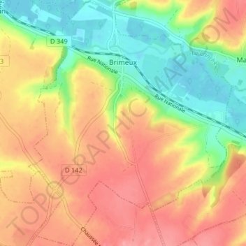
Name: Brimeux topographic map, elevation, terrain.
Average elevation: 49 m
Minimum elevation: 3 m
Maximum elevation: 89 m
Thank you for supporting this site ❤️
Make a donation
Make a donation
Other topographic maps
Click on a map to view its topography, its elevation and its terrain.
Thank you for supporting this site ❤️
Make a donation
Make a donation
Cap Gris-Nez
Frankrijk > Hauts-de-France > Pas-de-Calais > Audinghen > Le Gris-Nez
Average elevation: 14 m
Thank you for supporting this site ❤️
Make a donation
Make a donation
Plage d'Audreselles
Frankrijk > Hauts-de-France > Pas-de-Calais > Audresselles
Average elevation: 13 m
Thank you for supporting this site ❤️
Make a donation
Make a donation