
Thank you for supporting this site ❤️
Make a donation
Make a donation
Keno City topographic map
Click on the map to display elevation.
Thank you for supporting this site ❤️
Make a donation
Make a donation
About this map
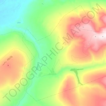
Name: Keno City topographic map, elevation, terrain.
Location: Keno City, Yukon, Canada (63.88464 -135.36395 63.96843 -135.15371)
Average elevation: 1,129 m
Minimum elevation: 689 m
Maximum elevation: 1,761 m
Thank you for supporting this site ❤️
Make a donation
Make a donation
Other topographic maps
Click on a map to view its topography, its elevation and its terrain.