
Thank you for supporting this site ❤️
Make a donation
Make a donation
Delbarton topographic map
Click on the map to display elevation.
Thank you for supporting this site ❤️
Make a donation
Make a donation
About this map
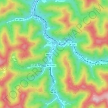
Name: Delbarton topographic map, elevation, terrain.
Location: Delbarton, Mingo County, West Virginia, 25670, United States (37.69260 -82.20008 37.72150 -82.15030)
Average elevation: 377 m
Minimum elevation: 214 m
Maximum elevation: 591 m
Thank you for supporting this site ❤️
Make a donation
Make a donation
Other topographic maps
Click on a map to view its topography, its elevation and its terrain.