
Make a donation
Neuenbürg topographic map
Click on the map to display elevation.
Make a donation
Neuenbürg
The township (Stadt) of Neuenbürg covers 28.17 square kilometers (10.88 sq mi) of the Enz district, within the state of Baden-Württemberg and the Federal Republic of Germany. It is physically located on the Pfinzhügelland [de], on the southern reaches of the Kraichgau. The geological makeup of the municipal area is decided by the meeting of the Pfinzhügelland's muschelkalk and keuper and the Black Forest's buntsandstein plateaus. The main watercourse is the Enz, which flows in a deep bed of Middle Buntsandstein [de]. Where the Enz flows into Birkenfeld marks the lowest elevation above sea level in the municipal area, 309 meters (1,014 ft) Normalnull (NN). The highest is the top of the Heuberg, south of Dennach, at 709 meters (2,326 ft) NN.
Make a donation
About this map
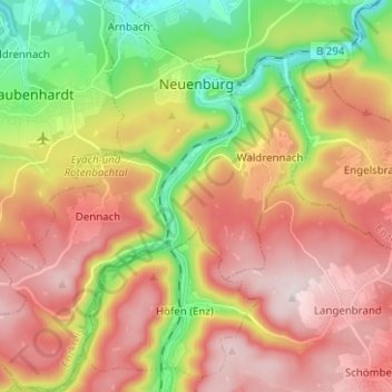
Name: Neuenbürg topographic map, elevation, terrain.
Average elevation: 518 m
Minimum elevation: 286 m
Maximum elevation: 727 m
Make a donation
Other topographic maps
Click on a map to view its topography, its elevation and its terrain.
Holzbachtal
Germany > Baden-Württemberg > Enzkreis > Straubenhardt > Langenalb
Average elevation: 449 m
Make a donation