
GZ Buchegg topographic map
Interactive map
Click on the map to display elevation.
About this map
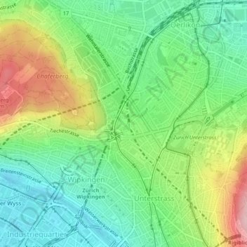
Name: GZ Buchegg topographic map, elevation, terrain.
Average elevation: 474 m
Minimum elevation: 398 m
Maximum elevation: 606 m
Other topographic maps
Click on a map to view its topography, its elevation and its terrain.
Industriequartier
Industriequartier, Zurich, District de Zurich, Zurich, 8005, Suisse
Average elevation: 428 m