
Montemuro topographic map
Interactive map
Click on the map to display elevation.
About this map
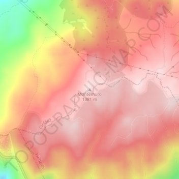
Name: Montemuro topographic map, elevation, terrain.
Average elevation: 1,277 m
Minimum elevation: 1,041 m
Maximum elevation: 1,366 m
Other topographic maps
Click on a map to view its topography, its elevation and its terrain.
Gralheira
Portugal > Norte > Alhões, Bustelo, Gralheira e Ramires > Gralheira
Gralheira, Alhões, Bustelo, Gralheira e Ramires, Cinfães, Viseu, Tâmega e Sousa, Norte, Portugal
Average elevation: 1,186 m
Alhões
Portugal > Norte > Alhões, Bustelo, Gralheira e Ramires > Alhões
Alhões, Alhões, Bustelo, Gralheira e Ramires, Cinfães, Viseu, Tâmega e Sousa, Norte, Portugal
Average elevation: 1,120 m
Bustelo
Portugal > Norte > Alhões, Bustelo, Gralheira e Ramires > Bustelo
Bustelo, Alhões, Bustelo, Gralheira e Ramires, Cinfães, Viseu, Tâmega e Sousa, Norte, Portugal
Average elevation: 887 m