
Villas La Montagne topographic map
Interactive map
Click on the map to display elevation.
About this map
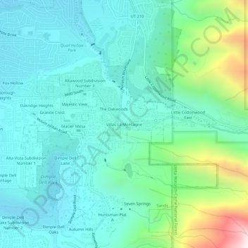
Name: Villas La Montagne topographic map, elevation, terrain.
Average elevation: 1,690 m
Minimum elevation: 1,453 m
Maximum elevation: 2,569 m
Other topographic maps
Click on a map to view its topography, its elevation and its terrain.
Wallace Heights
United States > Utah > Salt Lake County > Sandy
Wallace Heights, Sandy, Salt Lake County, Utah, 84070, United States
Average elevation: 1,346 m
Hillborough Heights
United States > Utah > Salt Lake County > Sandy
Hillborough Heights, Sandy, Salt Lake County, Utah, 84093, United States
Average elevation: 1,501 m
Sandy Hills
United States > Utah > Salt Lake County > Sandy
Sandy Hills, Canyon View Estates, Sandy, Salt Lake County, Utah, 84090, United States
Average elevation: 1,436 m
Dimple Dell Oaks
United States > Utah > Salt Lake County > Sandy
Dimple Dell Oaks, Sandy, Salt Lake County, Utah, 84092, United States
Average elevation: 1,622 m
Dry Creek
United States > Utah > Salt Lake County > Sandy
Dry Creek, Sandy, Salt Lake County, Utah, 84070, United States
Average elevation: 1,378 m
Granite Park
United States > Utah > Salt Lake County > Sandy > Granite Crest
Granite Park, Granite Crest, Sandy, Salt Lake County, Utah, United States
Average elevation: 1,534 m
Southern Charm
United States > Utah > Salt Lake County > Sandy
Southern Charm, Sandy, Salt Lake County, Utah, 84070, United States
Average elevation: 1,397 m
Storm Mountain Terrace
United States > Utah > Salt Lake County > Sandy
Storm Mountain Terrace, Sandy, Salt Lake County, Utah, 84020, United States
Average elevation: 1,392 m
Kester
United States > Utah > Salt Lake County > Sandy
Kester, Sandy, Salt Lake County, Utah, 84070, United States
Average elevation: 1,370 m
Sandy Heights South
United States > Utah > Salt Lake County > Sandy
Sandy Heights South, Sandy, Salt Lake County, Utah, 84070, United States
Average elevation: 1,371 m
Sandy
United States > Utah > Salt Lake County > Sandy
Sandy, Salt Lake County, Utah, 84094, United States
Average elevation: 1,827 m
Hickory Valley
United States > Utah > Salt Lake County > Sandy > Hickory Valley
Hickory Valley, Sandy, Salt Lake County, Utah, 84020-5626, United States
Average elevation: 1,534 m
Sandridge
United States > Utah > Salt Lake County > Sandy > Sandridge
Sandridge, Sandy, Salt Lake County, Utah, 84094, United States
Average elevation: 1,441 m