
Make a donation
Royston topographic map
Click on the map to display elevation.
Make a donation
About this map
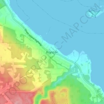
Name: Royston topographic map, elevation, terrain.
Average elevation: 29 m
Minimum elevation: -1 m
Maximum elevation: 113 m
Make a donation
Other topographic maps
Click on a map to view its topography, its elevation and its terrain.
Denman Island
Canada > British Columbia > Comox Valley Regional District > Area A (Baynes Sound)
Average elevation: 36 m
Hornby Island
Canada > British Columbia > Comox Valley Regional District > Area A (Baynes Sound)
Average elevation: 27 m
Tsable Lakes Woodlands
Canada > British Columbia > Comox Valley Regional District > Area A (Baynes Sound)
Average elevation: 556 m
Rosewall Creek Provincial Park
Canada > British Columbia > Comox Valley Regional District > Area A (Baynes Sound)
Average elevation: 39 m
Make a donation
Beaufort Range
Canada > British Columbia > Comox Valley Regional District > Area A (Baynes Sound)
Average elevation: 435 m